Monday, 25 July 2011

Namibia Part 3 - The South

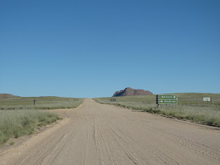
We decided to spend the next night at a Lodge in the Zebra mountains.  We found the place in one of our travel books, and one of the selling points was the good cooking of the hostess.  We had some nice river crossings, and finally entered a farm gate. 
 
  As we were driving in I saw a farm house on a koppie. I said to Hennie he must flash his car lights at Carl-Hein that we can turn around, as I was not staying in the farm house for R900 a person a night. As usual Hennie is not prone to over reacting, so he travelled on.  Soon we encountered the sign below and it set my mind at ease.  Obviously other people have been scared away before...

 We had a bit of a "twilight zone" experience at the Lodge.  After we extended their welcoming drink to four drinks by filling up our G&T's from the car, the host joined us.  He soon decided he needed to catch up and by dinner time he was thoroughly drunk.  Also, it transpired that him and his wife acquired the Lodge from the previous owners some two years ago, and that our guide books were out of date.  It was obvious that his wife did not have the cooking skills of the previous host.  All and all the stay was not bad, and it was nice to have a warm shower and a clean place to get dressed, and to sleep in a bed.

Stromatolites (some geological formation)
 We decided to sleep the next evening at the Seeheim hotel.  It is probably one of those things you have to do when in Namibia.  The place is however not "wheelchair" friendly, so I stay put in the bar most of the time.  What an interesting place, with lots of pictures of the history of the town of Seeheim and the hotel itself.
Train bridge at Seeheim
 Then we decided to call it quits, and dropped Mari-Louise and Carl-Hein to do the rest of the trip on their own.  It was just too difficult with the crutches, as I realised I was carrying way too much weight to drag along and my arms were killing me.
Crossing the Orange River back into South Africa


About 25km from home we cross the Olifants River, normally on a low-water bridge.  However, when we got there the bridge has disappeared under the water, and we had to take a small detour home.  It was great to get home, but I was sad that I missed probably the most important place on my agenda, namely Luderitz and Kolmanskop.  I hope that we will get the opportunity to go back there soon.
Olifants River

Sunday, 24 July 2011

Namibia - Sossusvlei

I thought we were going to die of cold at Sossusvlei.  We stayed at the Sesriem camping site.  We had the nicest site, and after the admin people saw my foot in plaster, they gave us a site quite close to the ablution blocks.  Normally not your best site, but if you have to go there on crutches you will understand the allure.  Unfortunately I had to cross the equivalent of Dune 45 to get to the toilets.  Hennie says I exaggerate, it was barely a molehill of sand.  Not in my mind.
 In the morning when we left the camp site at six, the temperature was minus two degrees.  But Hennie and I are optimists and believed the day would turn into a scorcher, and wore our shorts.  BIG MISTAKE.  As I could not climb Dune 45 to see the sunrise, we took a much slower approach into the park, and played with the camera in the low light conditions.  Unfortunately that did not pay off.  There was also no complaints from Hennie that we could not climb Dune 45.
Dune 45
The road into the park was as green as I have ever seen it.  It was beautiful.  The fairy circles were present in abundance, and lots of Gemsbok and Springbok were gawping at us (and we at them) as we drove by.


As we drove the last 5 km to Sossusvlei proper, the frost was still lying thick on the sand ridges.  It was not even necessary to deflate the tyres.  The previous time we were there we encountered so many vehicles that got stuck in that thick sand, and now it was the opposite.


 After our trip into the park we went back to the camp site.  We were all still frozen, and Carl Hein realised that his gas bottle was running on empty.  As Anita and Adri were leaving us on that day, it did not bode well for the rest of us.  We were planning to cook pasta on the gas stove that evening, and it also meant no warm coffee the next morning.  In addition, we had a bit of an incident at the gate the previous night, and all of thus motivated us to find alternative accommodation for the coming night.  But mostly it was me that said I CANNOT camp any more.  It feels terrible to sit in a chair and someone else has to pack everything, and still bring my anything I need in the mean time.  Also, Hennie does not have the patience to pack things were they belong, and I saw the back of the car was degenerating into a big pile of camping stuff and clothes.  So we consulted our travel journals to find a suitable alternative...


 Sossusvlei itself was full of water, which was quite a contrast from our previous visit.  I was glad that I have been there before, as it would have been a big disappointment going there and not seeing anything.

Sossusvlei
Poor me.


The case of the wrong GPS co-ordinates

So I was in charge of entering the GPS coordinates for our 4x4 trip in the north of Namibia.  And I did a bloody fine job, I may say.  Until THAT DAY.
We were travelling the Gemstone Route skirting the western side of the Brandberg.  This was a trip especially for Hennie, who loves rocks.  It was clear from the very faint tracks that not many other people loves rocks that much, and we almost missed the turn-off.  The road got worse and worse.  We were aiming for the first co-ordinate.  The Fortuner was travelling in front, finding the way for everyone else. Adri does not have a GPS, and Carl-Hein complained that the routes are not on their GPS. Every now and again Hennie stopped to get out and look at rocks, and started filling the car with various samples.

In my defence I can say that we do not travel much with the GPS off-road.  Thus I missed the warning signs.  The GPS was showing a very winding route, and the next moment there was this line perpendicular to the route, straight as an arrow, to the GPS point.  If I knew more I would have been suspicious.  As luck would have it, right at the point where this straight line departs our route, you could almost imagine there has been a road, some 500 years ago.  Soon the road disappeared, but we found some other faint traces of a road, so we back-tracked a bit and followed the new road.  We were no longer on the GPS indicated line, but we have been off the GPS tracks numerous times before on the trip, so no alarm bells yet.  Soon that road also ran out, and it was clear from the rocks in front of us that no vehicle can go beyond that point.

Hennie and Anita decided that since we have come this far, they are going to walk the approximately 1 km to the GPS indicated point.  The rest of us stayed behind at the cars to talk crap and do nothing.  In the end we got bored of that as well, and the remainder of us went back to our respective cars to do  nothing there.  After what felt like an hour or even hour and a half, we saw Hennie and Anita approaching.  At the same time Mari-Louise came to me to ask if I was sure I entered the GPS point correctly, as according to their GPS the point lies on the road we were travelling, before we turned off.  Seems she was right.  I put the NS coordinate of the first marker, and the EW point of the second marker in.  Hennie and Anita was walking to nowhere.

In the mean time Carl-Hein decided it was an opportune moment to go off on morning ablutions, with his shovel, toilet paper and lighter.   Of course he did not tell anyone what he was going to do.   Just when Hennie and Anita rejoined us, we heard Carl-Heins screams in the distance.  We could see him, but we could not hear what he was shouting.  He was clearly in distress from the tone of his voice.  He was jumping up and down on his one foot  and waving his shirt in the air.  I just knew there was trouble.  Do not know who first interpreted it, but the message came through that he has been bitten by a snake. HKGK.  In my mind Carl-Hein was a goner.  It would take us probably at least 4 hours to get to any civilisation or cell phone reception.  We did not have anti-venom with us.

Mari-Louise set off at a pace, and halfway through the distance to Carl-Hein she could finally hear what he was shouting.  BRING DIE BRANDBLUSSER.  Not sure why she ran back, fetched the extinguisher, and sprinted back.  The next moment she trips on a rock and falls down face first.  Hennie did not think she was going to get back up, but the next moment she is up and running again.  The rest are following a distant second, and I was still trying to get our extinguisher out of our car (Yes, our car would have burned down by the time I finally wrestled the damn thing out of its holding place).  When Carl-Hein wanted to burn his toilet paper the felt caught fire.  He could not believe how fast it happened, and he was worried about the cars, as the fire would be in our escape path.  The flames were all around him, and he could do nothing.

Luckily they could stop the fire.  Carl-Hein hurt his big toe (he has already hurt some other toes previously in the trip).  Poor Mari-Louise was bruised and grazed from her shins to her chin from her fall.  She looked terrible.

And everyone blamed me...

Namibia Holiday Part 2 - the North

En route to Henties Bay we passed by Wlotzkasbaken.  Hennie’s childhood memories of this bohemian town proof to be a bit inaccurate, or maybe they moderated over time.  The Wlotzkasbaken settlement was established during the early 1930’s when local fishermen started erecting temporary housing structures.  The settlement still mirrors these unique temporary houses each with its own water tank (colour coded to match the house) and power source.  The houses are colourful and quirky built from all manner of materials.  It would seem that the current 110 homeowners are locked in a legal battle with the local authorities with regard to the nature of the settlement and freehold titles. 

Shortly after Cape Cross (to be avoided if you have a sensitive stomach or keen sense of smell) we turned off at a very feint twee-spoor tract westwards.  Again lots of drainage ditches and some corrugation the closer we go to Messum Crater.  The crater is massive and from the outside it is quite difficult to visualise.  However, once inside (and obviously your brain now knows you are inside a crater), you can actually recognise the rim.  The inside comprised massive grassland with some rock formations in the centre of the crater.  There are bushmen signs and the remnants of an ancient Damara settlement in the form of rock circles.  The flats are scattered with gigantic welwitchia plants, many eons old.  Then we entered the Messum River bed.

Finally, just when we thought we may not make it to the Ugab River before nightfall, we turn onto a “main” road (dirt road) that took us to within 10km of the Ugab River.  There is a river camp run by the Save the Rhino Trust in collaboration with the local community.  Camp sites are neatly demarcated with a reed fence, and there are long drops and donkey powered showers at each camp site.  The rocks next to our camp site were turned a bright golden colour by the setting sun, and we marvelled at the mountain chats flirting about.  At a measly 45 Namibian Dollar per person per night, this was real value for money, and is worth supporting. 

Sunrise at Ugab River Camp
We stayed on the road after this warning


Gem stone route - mining town


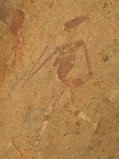
The next day we travelled anti clockwise around the Brandberg, through Uis and then slept at the north eastern side of the Brandberg.  We had quite a nice campsite and it was the first night that we did not sleep in our tent.  The next morning we did the hike up into the mountain to see the famous White Lady bushmen paintings.  The walk there was an absolute delight and is highly recommended.  The Birders among us managed to identify quite a few novel birds and a "lifer" or two.


Ruppel's korhaan
camp site at White Lady Lodge
Running repairs
En route to bushmen paintings - river crossing


"White Lady"


The next day we departed for Spitzkoppe.  Our planned route was closed due to river damage, and we had to take a slight detour.  It was amazing to see the majestic Spitskoppe raise from the surrounding plains from quite a distance.  There is a community camp at Spitskoppe, but I have to admit that it was not a very nice campsite.  There are no ablution blocks, and apparently the available long drop was to be avoided.


We decided to go for a sundowner on a few rocks at Spitskoppe.  Before we even started climbing I stepped on a loose rock and managed to hurt my foot.  It was terribly painful, but everyone was so good back at camp looking after me that it made it more bearable.  Hoping it was just a bad sprain I went to bed with the firm hope (but not the belief) that all will be fine in the morning.  The night was quite arduous and the next morning Hennie and I travelled to Swakopmund to see if it can be fixed with a proper bandaging.  We first went to the hospital - not to be recommended.  It took a while to be helped, and then to hear that there is no doctor available at ER, we went to town to find a doctor.  As we walked into the doctor's room the first question was whether this was a quad bike accident.  Apparently they see lots of those.  The doctor was very nice, and told me that I have torn some ligaments, muscles and soft tissue and that I must stay off the foot for the next 4 weeks.  He then put on a cast that I could take off to shower and handed me some crutches.  Not what I wanted to hear.

We then drove on to Sossusvlei, where we met up with the other two vehicles.